1/5


Hiking Project
1K+下载次数
17MB大小
24.43.1(25-10-2024)最新版本
详情评价版本信息
1/5
Hiking Project介绍
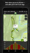
无论您身在何处,远足计划都是您附近最佳远足的综合指南。
借助打印地图的完整性,我们提供了完整的GPS路线信息,海拔剖面,互动功能,照片等。像一本指南一样,我们建议您在当前位置附近或搜索区域内探索最有特色的远足。当地专家会向您展示亮点,具有挑战性的功能以及您在小径上计划美好一天所需要的见解。
•寻找超过74,000英里的步道,与您的船员一起远足。
•新的足迹不断添加到我们难以置信的详细远足数据库中。
•您的确切位置显示在路径上。
•当您不在网格中时,下载的路径可以脱机工作。 (无需接收细胞!)
•欣赏高分辨率照片和详细的地形图。
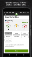
•我们将与您的待办事项同步,并在HikingProject.com上签到。
通过使用GPS,我们可以在步道和垂直剖面上显示您的位置。继续使用在后台运行的GPS会大大降低电池寿命。
链接:
•隐私政策:https://www.adventureprojects.net/ap-privacy
•服务条款:https://www.adventureprojects.net/ap-terms
保证非恶意应用此应用已通过病毒、恶意软件和其他恶意攻击的安全测试,不含任何威胁。
Hiking Project - APK信息
APK版本: 24.43.1程序包: com.hikingproject.android名称: Hiking Project大小: 17 MB下载次数: 25版本: 24.43.1发布日期: 2025-01-24 16:58:38最小屏幕: SMALL支持的CPU:
程序包ID: com.hikingproject.androidSHA1签名: 09:8F:1E:98:3B:FE:3C:97:1A:C0:0A:62:97:1A:23:F7:69:A2:3F:5D开发商 (CN): Sam Vanderhyden组织 (O): 本地 (L): Victor国家/地区 (C): US州/市 (ST): ID程序包ID: com.hikingproject.androidSHA1签名: 09:8F:1E:98:3B:FE:3C:97:1A:C0:0A:62:97:1A:23:F7:69:A2:3F:5D开发商 (CN): Sam Vanderhyden组织 (O): 本地 (L): Victor国家/地区 (C): US州/市 (ST): ID
Hiking Project的最新版本
24.43.1
25/10/202425 下载次数12 MB 大小
其他版本
24.43.0
21/10/202425 下载次数12 MB 大小
24.38.0
7/10/202425 下载次数11.5 MB 大小
24.26.0
1/7/202425 下载次数14 MB 大小
24.25.0
28/6/202425 下载次数14 MB 大小
24.19.1
28/5/202425 下载次数13.5 MB 大小
24.19.0
28/5/202425 下载次数13.5 MB 大小
24.9.0
4/3/202425 下载次数11.5 MB 大小
24.2.0
4/3/202425 下载次数6 MB 大小
23.51.0
24/12/202325 下载次数6 MB 大小


同类应用


English


